When a volcano in the South Pacific Ocean erupted in January 2022, NOAA researchers were well-equipped to study the multi-hazard event by sky and by sea. Key technologies and strategic partnerships made it possible for NOAA to issue warnings that saved lives around the world, while also collecting scientific data that will improve forecasting models and disaster response for future events.
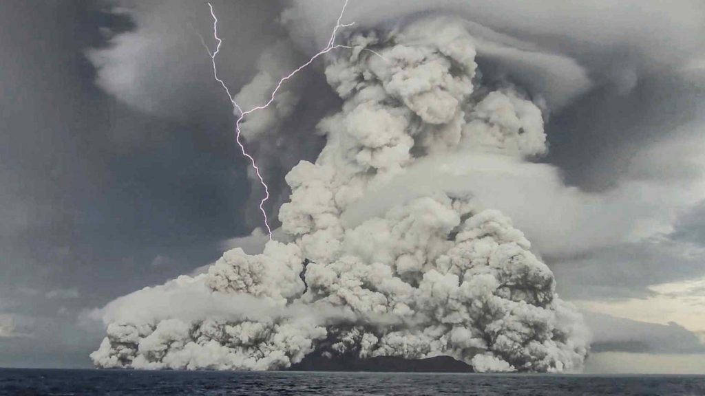
Blasts from the Hunga Tonga – Hunga Ha’apai volcano launched ash and toxic gas high into the stratosphere to altitudes above 30 km. The plume of material formed an umbrella cloud 500 km wide and triggered record-breaking amounts of lightning strikes. The violent eruption provided a rare opportunity for scientists to learn more about sulfur dioxide gas emissions in the stratosphere.
The Hunga Tonga - Hunga Ha'apai volcano erupted on 15 January 2022. Photo: Tonga Geological Services
As the sulfur plume traveled westward, researchers from NOAA Chemical Sciences Laboratory, CIRES, and the University of Houston gathered on La Réunion island in the Indian Ocean, about 8,000 miles away from the initial volcanic blast. The plan was to use specially-designed balloons to lift lightweight aerosol sensors high up into the stratosphere, where they could collect air quality data as the plume passed overhead. NOAA’s satellites tracked the movement of the volcanic cloud, and the scientific team worked quickly to prepare.
The scientific sensors attached to the balloons were Portable Optical Spectrometers, or POPS. POPS were invented at NOAA’s Chemical Sciences Laboratory and then licensed to a small manufacturing company called Handix Scientific. Licensing the technology meant that the device could be improved, commercialized, and made available to researchers worldwide in large quantities. Thanks to this successful technology transfer, NOAA scientists were able to quickly order and ship many units of POPS and complete their mission.
A week after the explosion, the plume arrived above the island’s high-altitude Maïdo Atmospheric Observatory. The research team was ready with their equipment. Scientists successfully launched the balloons and are now using the data to refine atmospheric models. This series of events marked the quickest scientific response to a volcanic eruption to date, and the data will improve researchers’ collective understanding of how volcanic explosions affect the Earth’s atmosphere. Without the licensing agreement in place, this once-in-a-lifetime opportunity would have been lost.
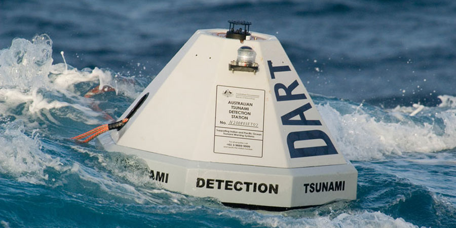
Meanwhile, half a world away in the Pacific Ocean Basin, the eruption generated ocean waves that rippled around the planet and set off widespread tsunami advisories. The alerts were triggered by a network of Deep-ocean Assessment and Reporting of Tsunamis (DART) buoys, which are positioned strategically throughout the ocean and send real-time data to tsunami warning centers. After the volcanic eruption, DART buoys recorded the propagating tsunami waves and prompted critical tsunami alerts for many coastlines that were later flooded.
DART buoys detect tsunami waves and transmit real-time sea level information measurements back to the Tsunami Warning Centers.
The DART buoy system was originally designed and developed at the NOAA Pacific Marine Environmental Laboratory. The system was patented and licensed to a private company, Science Applications International Corporation, so they could market and sell DART buoys worldwide. This invaluable network has been in place for decades and is a critical component of the life-saving NOAA Tsunami Warning System.
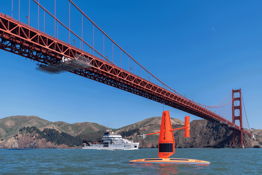
At the time of the volcano eruption, while the DART buoy network recorded tsunami wave data, two uncrewed ocean drones happened to be positioned in the Pacific Ocean collecting data for a NOAA research mission. The mission was one of many ongoing collaborations between NOAA and the drone manufacturer, Saildrone. NOAA’s public-private research partnership with Saildrone allows the two collaborators to share ideas, expertise, and other materials while they jointly conduct research and further develop drone technologies that benefit society. This research partnership has produced significant economic benefits for Saildrone, and has provided the basis for ongoing NOAA missions using Saildrone vehicles.
A Saildrone collects data beneath the Golden Gate Bridge, alongside a NOAA research vessel. Image by Saildrone.
The Saildrones that were deployed in the Pacific Ocean during the volcanic explosion were able to detect jumps in atmospheric pressure and capture crucial information in an observationally-sparse region of the ocean. This data is particularly valuable because only about 5% of tsunamis are generated from volcanic activity, rather than earthquakes. The high-resolution measurements from the drones, coupled with the records from the DART buoys, will help scientists better understand these types of rare events and incorporate volcano-induced tsunamis into the model used to inform hazard response to tsunamis.
Impacts of climate change are affecting communities worldwide, and scientists predict that many types of natural disasters and hazards are likely to become even more intense in the coming decades. A core part of NOAA’s mission is to build a Climate Ready Nation, in which people share an understanding of climate change and work together to address the climate crisis. Innovative technologies and strategic research partnerships are central to accomplishing this mission because they allow NOAA to deliver cutting-edge research and science-driven services that help build community resilience, promote economic growth, and keep people safe.
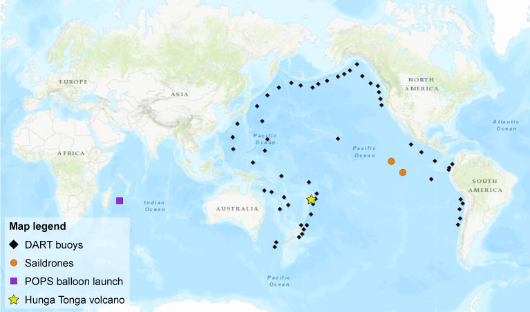
Map showing the positions of DART buoys, NOAA Saildrones, and the POPS launch, relative to the Hunga Tonga volcano.
Technologies and research partnerships enabled NOAA’s multifaceted, unprecedented response to the Hunga Tonga – Hunga Ha’apai volcanic eruption. The NOAA Technology Transfer Program within the Technology Partnerships Office helps NOAA scientists set up cooperative research agreements, such as the collaboration with Saildrone. These partnerships allow NOAA scientists and private sector partners to work together to conduct research and transform new science into products and services that benefit the public.
The Technology Transfer Program also helps move NOAA’s inventive technologies, such as the POPS devices and DART buoys, out of NOAA labs and into the hands of private companies that push the technologies to the next level so they can be put to use worldwide. NOAA’s technology transfer activities are already having enormous impacts globally, and these efforts will become even more important as NOAA continues to leverage technologies and partnerships to research and respond to natural disasters and help build a Climate Ready Nation.
Note: Any reference obtained from this website to a specific company, product, process, or service does not constitute or imply an endorsement by NOAA.