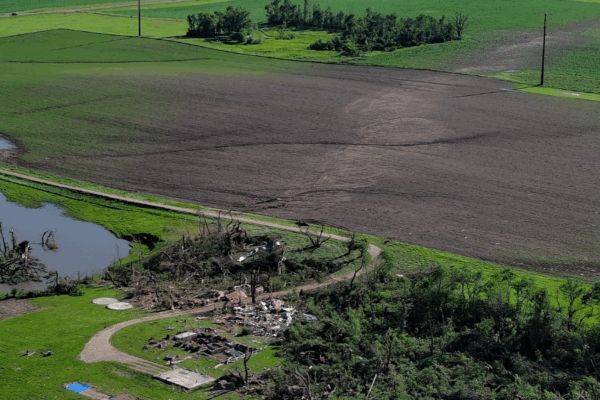
Severe thunderstorms in the United States can be catastrophic, threatening lives and ultimately costing billions of dollars in damages every year. Tornadoes in particular can be a significant threat across the U.S., and especially in the southern states where half of the nation’s severe thunderstorm, flash flood, and tornado events occur.
NOAA’s National Weather Service (NWS) weather forecast offices provide critical daily forecasts, warnings, and storm surveys in their communities. To forecast severe storms, meteorologists use data from Doppler radar, satellites, real-time observations, and complex forecast models to issue alerts. Equally as critical can be post-storm surveys, where damage assessments reveal tornado intensity, storm impacts, and research can be conducted to improve future warning systems. This all supports the NWS mission to protect lives, property, and the economy.
The NWS and Disaster Imaging, Inc. (DII) recently signed a Cooperative Research and Development Agreement, or CRADA, to explore using drones to conduct damage assessments after severe storms. Specifically, the two organizations will perform collaborative research and development on the fast deployment of “uncrewed aircraft systems” or UAS (colloquially known as drones) to collect and distribute aerial images of the damage done by severe storms.
“We are excited to be working with Disaster Imaging, Inc to explore the rapid deployment of drones to survey tornado events,” said Tim Oram, Chief of the Science and Technology Services Division at NWS Southern Region. “NWS post-storm surveys provide information for both evaluating the quality of our current warnings and creating the data for research needed to increase our warning lead times in the future. This partnership with DII will help evaluate the use of drones for transforming our post-storm damage assessment process to more quickly and efficiently provide these critical post-storm assessments.”
Disaster Imaging, Inc. is well suited to address the need for better, faster post-storm damage assessments. The company provides uncrewed UAS platforms, sensors, and personnel resources needed to rapidly respond and collect aerial imagery of storm damage. Their mission is to help better protect people and property from major storms through sharing the images they gather and partnering with agencies like NWS.
“We appreciate the opportunity to collaborate with the NWS to survey tornado events,” said Erik Rasmussen, Research Scientist at Disaster Imaging, Inc. “This interaction helps us focus on areas that will yield the most new insights into tornadic winds and how tornadoes interact with the terrain and land cover. By sharing these findings, we hope to contribute to NOAA’s work to improve future warning systems.”NOAA regularly partners with private sector companies through CRADAs to conduct research and development work that is mutually beneficial and helps to accomplish NOAA’s mission. NOAA CRADAs are coordinated through NOAA Research’s Office of Research, Transition, and Application (ORTA) Technology Partnerships Office.