WindTL
The Technology
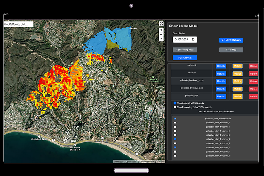
WindTL, developed by Improving Aviation, is a decision support tool designed for real-time situational awareness, pre-fire risk assessment, and predictive wildfire modeling. Backed by NASA, NOAA, and Google, WindTL leverages AI-powered models to deliver accurate wildfire spread, ember behavior, and ignition risk predictions, equipping field personnel with the intelligence needed to make proactive, data-driven decisions.
What Sets WindTL Apart?
- Pre-Fire Risk & Scenario Planning: Identifies high-risk wildfire zones and simulates fire behavior using AI and physics-based models, enabling strategic mitigation and resource optimization before ignition.
- Advanced Ember Spread Prediction: Forecasts ember movement, addressing the primary cause of wind-event driven wildfires and enabling targeted prevention efforts.
- Modular Situational Awareness: Integrates real-time from UAS, sensors, satellites, and weather feeds into the wildfire models and generates a real-time operational picture for better coordination and decision-making.
- Reliable & Scalable: Integrated with a robust cloud architecture, ensuring near-real time processing and scalability.
- Integrated with External Systems: WindTL is integrated with TAK and 3rd party GIS systems.
Applications
Pre-Fire Risk & Preventive Mitigation
- High-Risk Ignition Mapping: Uses machine learning to predict fire-prone areas based on fuel conditions, terrain, and historical data.
- Scenario Modeling & Prevention: Simulates wildfire spread under different conditions, guiding pre-fire mitigation efforts and prescribed burn planning.
- Urban-Wildland Interface Protection: Identifies at-risk communities, enabling early evacuation orders.
Active Wildfire Management & Emergency Response
- Real-Time Fire Tracking: Updates wildfire models using satellite imagery, weather data, and UAS reconnaissance.
- Resource & Evacuation Planning: Optimizes response strategies by predicting ember-driven ignitions near residential areas.
- Public Safety Alerts: Enhances early warning systems to mitigate wildfire risks.
Benefits
- Proactive Wildfire Management: Pre-fire risk mapping and real-time scenario planning to improve proactive mitigation strategies.
- Optimized Resource Allocation: Tracks personnel, vehicles, and firefighting assets, ensuring efficient deployment.
- Full Situational Awareness Combines field sensor data, UAS imagery and weather, and ground personnel inputs to update the wildfire prediction.
- Advanced Wildfire Spread & Ember Modeling: Combines physics-based with machine learning models to predict fire behavior and ember ignition.
- Integrated with a Portable Airspace Management System: WindTL is integrated via TAK, with an in-house airspace management tool that enhances airspace awareness and reconnaissance, supporting safe and autonomous operations.
Resources
Company Contact
This technology is commercially available for purchase. For additional information please contact Rocio Frej Vitalle at rocio@improvingaviation.com.
Note: Any reference obtained from this website to a specific company, product, process, or service does not constitute or imply an endorsement by NOAA.
Federal Procurement – Sole Source Information
Through the SBIR/STTR Congressional Authority and Policy Directive, companies are eligible for Phase III sole-source contracts to support work that derives from, extends, or completes work funded with SBIR Phase I or Phase II awards. Technologies in the Marketplace that include this statement are eligible for Phase III awards from any federal agency. For more information about Phase III, see this website and reach out to noaa.sbir@noaa.gov with questions. Find a full list of available SBIR/STTR technologies, access the Award Database on SBIR.gov.