Official websites use .gov
A .gov website belongs to an official government organization in the United States.

Secure .gov websites use HTTPS
A lock ( ) or https:// means you’ve safely connected to the .gov website. Share sensitive information only on official, secure websites.

Technology Partnerships Office News

Parent category for all the TPO news items – category feeds the TPO general newsroom.

A black drone with an orange base set on a beach.

HABMapper

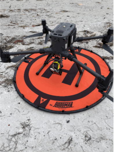
Background When algae grows rapidly and excessively, it is called a “bloom.” Algal blooms can produce toxins invisible to the naked eye. These blooms are harmful because the highly potent toxins of some algae species can cause direct harm to people, animals, fish, and ecosystems. They can also cause indirect harm, such as when blooms decompose and remove oxygen from the water (hypoxia), suffocating fish and other aquatic life. HABs can occur not only in freshwater, but in marine ecosystems as well.  HAB toxins can contaminate drinking water, cause skin and respiratory irritation, and even lead to illness or death after eating contaminated seafood. They can be fatal to pets, livestock, and dry-land wildlife, and decimate fish populations. Because of the multifaceted nature of the harm caused by HABs, there is a massive opportunity for companies who want to partner with technical experts to help communities and local industries solve the challenges HABs present. Summary of the Invention HABMapper is a sensor that uses data from hundreds of wavelengths of light to locate or identify harmful algal blooms. It can be mounted on drones or other mobile platforms that lets users immediately detect the presence, location, and quantity of harmful or toxic algae in water near beaches or other bodies of water. A drone can fly around a body of water with a HABMapper attached, and the HABMapper will identify the presence of blooms that pose a risk. Small and self-contained, it can be deployed by hand, on a boat, or on a vehicle, and provides real-time HAB information that improves targeted water sampling and leads to better forecasts of human health risk. Licensing Information NOAA is seeking qualified licensees to manufacture and sell this technology, which is patent pending in the United States.  Interested parties should contact the NOAA TPO at noaa.t2@noaa.gov for more information. 

HABMapper Read More »

Aerial view of a storm approaching an island village along the coast.

NOAA Partnership with Silurian AI Leverages Machine Learning to Predict Tropical Cyclone Behavior

NOAA’s Atlantic Oceanographic and Meteorological Laboratory (AOML) and Silurian AI have established a partnership to advance AI-driven tropical cyclone forecasting, leveraging artificial intelligence and NOAA data to help predict, track, and mitigate the damage from extreme weather events.

NOAA Partnership with Silurian AI Leverages Machine Learning to Predict Tropical Cyclone Behavior Read More »

A line of people fishing off a wooden pier extending over blue water.

NOAA’s Southwest Fisheries Science Center partnership leverages AI to track and measure federally-managed fish

NOAA’s Southwest Fisheries Science Center recently signed a Cooperative Research and Development Agreement with Fishtechy, Inc.—a small business that helps anglers accurately measure the size of their catch—to develop the Fishtechy app for commercial and recreational anglers.

NOAA’s Southwest Fisheries Science Center partnership leverages AI to track and measure federally-managed fish Read More »

An aerial shot of a beachfront community with a dark red wave coming up under the water.

Doing well by doing good: How U.S. companies can benefit from mitigating Harmful Algal Blooms

Did you know that U.S. companies can license and commercialize NOAA technologies, bringing cutting-edge solutions to the marketplace? Some technologies currently available can help to combat a particularly noxious scourge – Harmful Algal Blooms.

Doing well by doing good: How U.S. companies can benefit from mitigating Harmful Algal Blooms Read More »

Explore more ocean, decrease the cost: NOAA partners with Aqua Satellite Inc. to expand autonomous underwater exploration

NOAA Office of Marine Sanctuaries and Aqua Satellite Inc. have signed a cooperative research and development agreement (CRADA) to develop and use uncrewed systems to explore NOAA marine sanctuaries to optimize collection of ocean data.

Explore more ocean, decrease the cost: NOAA partners with Aqua Satellite Inc. to expand autonomous underwater exploration Read More »