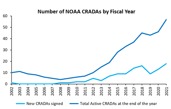
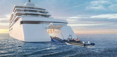
January 2022

Public-private research partnerships are fueling NOAA innovation

A record number of NOAA Cooperative Research and Development Agreements in 2021 has generated scientific and economic benefits Research partnerships are increasingly important as scientists work to address complex global problems like coastal resilience, food security, and climate change. Public-private partnerships, in particular, are vital for bringing private sector innovation and agility into NOAA’s research and development efforts. One of the key tools in NOAA’s partnership toolkit is the CRADA, or Cooperative Research and Development Agreement.  A CRADA is a formal agreement that allows federal and non-federal partners to do collaborative research and further develop new science into commercially-available products. CRADAs connect NOAA Laboratories or Science Centers with private U.S. companies, universities, and other entities, creating scientific partnerships across NOAA’s mission areas. CRADAs are valuable because they allow NOAA and non-federal partners to share ideas, technical expertise, facilities, and other research materials. The NOAA Technology Partnerships Office (TPO) is responsible for managing all of NOAA’s CRADAs. During Fiscal Year 2021, TPO initiated 18 new CRADAs, which is the highest number of these agreements ever to be started in one year at NOAA. This represents a 28% increase in the total number of new CRADAs from the previous fiscal year. Furthermore, NOAA and its research partners benefitted from a total of 57 active CRADAs this year, representing an increase of 24% from 2020. The number of CRADAs at NOAA is increasing as more federal researchers and non-federal partners see the value of existing public-private research and development efforts. Collaborations between NOAA and private-sector innovators accelerate research and development that supports both NOAA’s operations and commercialization within the private sector. This is important because more people can benefit from cutting-edge scientific discoveries and inventions when they are available on the commercial market. One example of an ongoing CRADA collaboration is NOAA’s partnership with U.S. biotechnology company, Prospective Research, Inc. NOAA researchers developed a probiotic to prevent disease in oysters and then began a public-private partnership with Prospective Research to further develop and test a freeze-dried version of the formula. The new shelf-stable probiotic has been shown to increase the survival rate of oyster larvae by 20-30% and is expected to be commercially available in 2022. The probiotic has the potential to increase sustainable aquaculture production worldwide. Another partnership between NOAA and the U.S. business, Saildrone, has simultaneously increased NOAA’s capacity to conduct innovative research and provide high-quality climate services, while also directly benefiting Saildrone and the U.S economy, more broadly. NOAA and Saildrone entered into a CRADA to explore how the company’s ocean drone technology could be further developed and strategically used to collect environmental data. Saildrone’s products have since been modified to support diverse NOAA research projects in the Arctic, across fisheries, around Antarctica, and even in the eye of a hurricane. The hurricane-equipped Saildrone Explorer was recently named one of the 100 Greatest Innovations of 2021. Video footage from on board Saildrone 1045 and animation showing location in Hurricane Sam on Sept. 30, 2021. As a result of this fruitful research partnership, NOAA scientists have been able to use the newly-collected data to improve storm forecasts, fisheries management, and climate services, while Saildrone has enjoyed a significant boom in business. According to a 2019 economic valuation study, during the three years after the 2014 CRADA with NOAA was established, Saildrone expanded their workforce from eight to over 100 employees and secured over $95 million in third-party investments into their technology. This influx of interest and sales can be partially attributed to the perceived scientific rigor associated with NOAA’s involvement in Saildrone’s product development. The economic benefits of Saildrone’s technology continue to increase– in October 2021, Saildrone announced the close of its $100 million Series C funding round. The company’s continued growth and success is creating jobs in several industries and is a significant asset for U.S. economies, especially in areas where Saildrones are created and deployed. While the NOAA-Saildrone partnership has been particularly successful, the cumulative impact of more than 50 active NOAA CRADAs underway cannot be overstated from either a scientific or an economic perspective. The collaborations increase NOAA’s capacity to do scientific research, while also stimulating technological innovation and generating broad economic value for the U.S. economy, the global New Blue Economy, and individual U.S. businesses. This economic impact was particularly important during the global COVID pandemic, so it is especially notable that NOAA reached its highest-ever annual number of new CRADAs during Fiscal Year 2021. Over the next year, TPO hopes to continue to expand NOAA’s use of CRADAs as a way to create partnerships. TPO is working with NOAA scientists and engineers to help them evaluate how a CRADA or other type of research partnership can most effectively support their research objectives. TPO also serves as the lead of the Partnerships Working Group under the Science and Technology Synergy Committee of the NOAA Science Council. TPO will continue to highlight the many ways that public-private partnerships support NOAA’s mission and stimulate innovation of new products bound for the commercial market. As scientific research is called upon to inform solutions for some of society’s most pressing challenges, partnerships are essential and CRADAs unlock enormous potential for collaborative problem-solving and innovation.

Exploring the Pacific Arctic Seasonal Ice Zone With Saildrone USVs

Exploring the Pacific Arctic Seasonal Ice Zone With Saildrone USVs More high-quality, in situ observations of essential marine variables are needed over the seasonal ice zone to better understand Arctic (or Antarctic) weather, climate, and ecosystems. To better assess the potential for arrays of uncrewed surface vehicles (USVs) to provide such observations, five wind-driven and solar-powered saildrones were sailed into the Chukchi and Beaufort Seas following the 2019 seasonal retreat of sea ice. They were equipped to observe the surface oceanic and atmospheric variables required to estimate air-sea fluxes of heat, momentum and carbon dioxide. Some of these variables were made available to weather forecast centers in real time. Our objective here is to analyze the effectiveness of existing remote ice navigation products and highlight the challenges and opportunities for improving remote ice navigation strategies with USVs. We examine the sources of navigational sea-ice distribution information based on post-mission tabulation of the sea-ice conditions encountered by the vehicles. The satellite-based ice-concentration analyses consulted during the mission exhibited large disagreements when the sea ice was retreating fastest (e.g., the 10% concentration contours differed between analyses by up to ∼175 km). Attempts to use saildrone observations to detect the ice edge revealed that in situ temperature and salinity measurements varied sufficiently in ice bands and open water that it is difficult to use these variables alone as a reliable ice-edge indicator. Devising robust strategies for remote ice zone navigation may depend on developing the capability to recognize sea ice and initiate navigational maneuvers with cameras and processing capability onboard the vehicles. View/Download Paper Andrew M. Chiodi, Chidong Zhang, Edward D. Cokelet, Qiong Yang, Calvin W. Mordy, Chelle L. Gentemann, Jessica N. Cross, Noah Lawrence-Slavas, Christian Meinig, Michael Steele, Don E. Harrison, Phyllis J. Stabeno, Heather M. Tabisola, Dongxiao Zhang, Eugene F. Burger, Kevin M. O’Brien and Muyin Wang

A UAV-based active AirCore system for measurements of greenhouse gases

A UAV-based active AirCore system for measurements of greenhouse gases We developed and field-tested an unmanned aerial vehicle (UAV)-based active AirCore for atmospheric mole fraction measurements of CO2, CH4, and CO. The system applies an alternative way of using the AirCore technique invented by NOAA. As opposed to the conventional concept of passively sampling air using the atmospheric pressure gradient during descent, the active AirCore collects atmospheric air samples using a pump to pull the air through the tube during flight, which opens up the possibility to spatially sample atmospheric air. The active AirCore system used for this study weighs ∼ 1.1 kg. It consists of a ∼ 50 m long stainless-steel tube, a small stainless-steel tube filled with magnesium perchlorate, a KNF micropump, and a 45 µm orifice working together to form a critical flow of dried atmospheric air through the active AirCore. A cavity ring-down spectrometer (CRDS) was used to analyze the air samples on site not more than 7 min after landing for mole fraction measurements of CO2, CH4, and CO. We flew the active AirCore system on a UAV near the atmospheric measurement station at Lutjewad, located in the northwest of the city of Groningen in the Netherlands. Five consecutive flights took place over a 5 h period on the same morning, from sunrise until noon. We validated the measurements of CO2 and CH4 from the active AirCore against those from the Lutjewad station at 60 m. The results show a good agreement between the measurements from the active AirCore and the atmospheric station (N = 146; R2CO2: 0.97 and R2CH4: 0.94; and mean differences: ΔCO2: 0.18 ppm and ΔCH4: 5.13 ppb). The vertical and horizontal resolution (for CH4) at typical UAV speeds of 1.5 and 2.5 m s−1 were determined to be ±24.7 to 29.3 and ±41.2 to 48.9 m, respectively, depending on the storage time. The collapse of the nocturnal boundary layer and the buildup of the mixed layer were clearly observed with three consecutive vertical profile measurements in the early morning hours. Besides this, we furthermore detected a CH4 hotspot in the coastal wetlands from a horizontal flight north to the dike, which demonstrates the potential of this new active AirCore method to measure at locations where other techniques have no practical access. View/Download Article   Andersen, T., Scheeren, B., Peters, W., and Chen, H.: A UAV-based active AirCore system for measurements of greenhouse gases, Atmos. Meas. Tech., 11, 2683–2699, https://doi.org/10.5194/amt-11-2683-2018, 2018.